If you picture Sugarloaf Key boating as simply “waterfront equals easy boating,” you could miss details that matter every day you own the property. The right home here depends on how you use your boat, where you want to go, and what kind of dock setup your vessel actually needs. When you understand access, bridge limits, dock types, and local compliance, you can buy with far more confidence. Let’s dive in.
Why boating fit matters
Sugarloaf Key sits within a highly managed marine environment, with the Florida Keys National Marine Sanctuary beginning at the mean high-water mark and protecting 4,539 square miles of surrounding waters. That means boating decisions here are tied not only to lifestyle, but also to navigation realities and protected-water rules.
For many buyers, the real question is not whether a property is waterfront. It is whether that specific waterfront location matches your boating plans. In Sugarloaf Key, buyers often weigh ocean access, canal shelter, backcountry-style routes, and dockage practicality all at the same time.
Compare ocean-side and canal access
Ocean-side lots and reef access
Ocean-side properties are often the best fit if you want quicker access to reef fishing, diving, and open-water cruising. For buyers who plan to spend time offshore, this can be one of the biggest day-to-day advantages of location.
That access comes with protected-water considerations. NOAA notes that sanctuary preservation areas protect reef habitat and provide mooring buoys so boaters can avoid anchor damage, which is especially relevant if your boating lifestyle includes reef stops near managed areas.
Canal and Bow Channel settings
Canal-front and Bow Channel locations can offer more shelter than open-water exposure. That can appeal to buyers who value calmer dockage conditions or want a more protected place to keep a smaller vessel.
Still, these settings can be less forgiving for larger boats. NOAA’s Coast Pilot reports that Bow Channel, between Sugarloaf Key and Cudjoe Key, has two fixed bridges with only 8 feet of vertical clearance, and the channel is not recommended for drafts over 2 feet without a pilot.
Match the property to your vessel
Boat size should shape your home search early. If you own a larger center console, a tower boat, or a sailboat, clearance and depth limits may rule out some otherwise appealing canal properties.
In those cases, the better question may be whether the property can support a lift that fits your vessel, or whether nearby marina storage makes more sense. On Sugarloaf Key, practical fit often matters more than a broad “waterfront” label.
Nearby boating destinations shape value
Looe Key and reef-oriented boating
Looe Key is one of the major nearby boating destinations that helps define Sugarloaf’s appeal. NOAA describes it as a 7.04-square-mile management area that includes the Looe Key Sanctuary Preservation Area and nursery restoration areas.
Diving, snorkeling, and boating are allowed in sanctuary preservation areas, but fishing, collecting, and anchoring on coral, or anchoring when a mooring buoy is available, are prohibited. If your ideal day on the water includes reef outings, those rules are part of the ownership equation.
Backcountry-style routes and protected areas
NOAA’s Coast Pilot notes that Cudjoe Bay, east of Bow Channel, offers fair holding ground for fishing boats. It also says the route north through Bow Channel toward Johnston Key Channel is shallow and current-prone.
That gives many buyers a clear lifestyle tradeoff. Some choose faster reef-side convenience, while others prefer more protected access that may work better for smaller vessels and backcountry-style boating.
Common dockage features in Sugarloaf Key
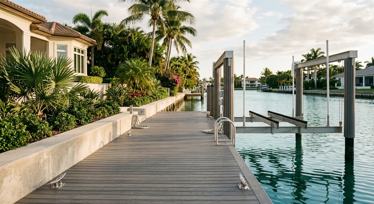
Monroe County permit records show a range of local dock setups, including elevator-style lifts, side-elevator lifts, davits, and kayak ramps. Recent Sugarloaf-area permits include examples for 7,000-, 10,000-, 13,000-, 15,000-, 17,000-, and 20,000-pound lifts.
Those records are not a list of active inventory, but they do show the kinds of vessel support systems commonly used in the area. They also suggest that local dockage is often designed around very specific boat sizes and launch preferences.
Dock design types to know
Monroe County policy distinguishes among marginal docks, T-style docks, and pier-type docks. The county also allows special exceptions when extra dock length is needed to reach adequate water depth.
That matters if you are evaluating a lot with challenging depth or planning changes after purchase. A property’s shoreline condition and dock layout can affect both usability and what may be possible through the local process.
Lift and tie-down requirements
County code says docks with lifts or davits need secure tie-down provisions. Dock designs also should not interfere with navigation.
This is one reason dockage evaluation should go beyond simple measurements in a listing. The most attractive setup is one that works safely, fits the lot, and supports the way you actually boat.
Permitting can affect your timeline
On the state side, the Florida Department of Environmental Protection’s ERP system allows self-certification for certain single-family dock projects. These may include new docks with or without lifts, repairs or replacements, and adding a lift.
Other projects may require an ERP and authorization to use state-owned submerged lands. Monroe County also has a dedicated Dock Length Special Exception application, so buyers considering improvements should factor permitting complexity into their planning.
Consider launch and marina alternatives
Not every buyer needs to keep a boat behind the house. Depending on your vessel, usage pattern, and the property’s access limits, nearby launch and service facilities may be part of the best solution.
FWC currently lists several Sugarloaf-area launch and service profiles, though it notes these entries are survey-based and conditions may have changed since the listed survey date.
Sugarloaf-area facilities
FWC lists the following local options:
- Sugarloaf Marina: paved ramp and fuel, with no docks or restrooms listed
- Sugarloaf Lodge and Marina: paved ramp, with no docks or restrooms listed
- Sugarloaf Key/Key West KOA: paved ramp, docks, fuel, bait, restrooms, handicap access, and a ship store
Nearby Lower Keys options listed by FWC include Cudjoe Gardens Marina, Dolphin Marina, Looe Key Reef Resort, and Geiger Key facilities. For some buyers, these alternatives make a home with less dockage flexibility easier to consider.
Pump-out and compliance matter too
In the Florida Keys, boating compliance is part of everyday ownership. Monroe County says the Florida Keys are within a federal No Discharge Zone and offers free keys-wide mobile pump-out service.
The county also requires proof of pump-out for vessels anchored or moored more than ten consecutive days if they are required to carry a marine sanitation device. That makes pump-out access and service logistics part of the dockage conversation, especially if you plan to keep your boat in place for extended periods.
Tall vessels need extra caution
Monroe County also maintains boating-restricted areas. FWC rule history notes that the Monroe County rule was adopted in part to reduce the risk of sailboat masts contacting high-tension power lines.
This is especially important if you own a sailboat or another tall-masted vessel. In Sugarloaf Key, vertical clearance is not just a bridge issue. It can also affect how safely and realistically you can navigate local waters.
What buyers should evaluate first
If boating is a priority, it helps to review a waterfront property through a practical lens before you fall in love with the view. A beautiful lot may still be the wrong fit if the route, depth, clearance, or dock setup does not match your boat.
Start with the basics:
- Your boat’s draft, beam, height, and lift needs
- Whether you want reef access, protected canal dockage, or backcountry-style routes
- Bridge and clearance limitations near the property
- Existing dock type, lift capacity, and tie-down setup
- Whether pump-out access and marina support matter for your boating routine
- Whether future dock changes may require a county or state approval process
Sugarloaf Key is about the right match
The best boating property in Sugarloaf Key is rarely just the one with water behind it. It is the one that aligns the lot’s exposure, the dock type the parcel can support, and the vessel you truly plan to keep there.
That kind of fit can make island ownership feel seamless instead of frustrating. If you want help comparing Sugarloaf waterfront options with a sharp eye on dockage, access, and everyday usability, Ally Kelley can help you navigate the details with a private consultation.
FAQs
What should I check first about boating access in Sugarloaf Key?
- Start with your boat’s draft, height, and size, then compare those needs with the property’s route to open water, bridge clearance, and existing dock setup.
Are canal-front homes in Sugarloaf Key good for larger boats?
- Some canal or Bow Channel locations may be more sheltered, but NOAA reports Bow Channel has two fixed bridges with 8 feet of vertical clearance and is not recommended for drafts over 2 feet without a pilot.
What dock features are common in Sugarloaf Key?
- Monroe County permit records show common setups such as elevator lifts, side-elevator lifts, davits, and kayak ramps, with lift examples ranging from 7,000 to 20,000 pounds.
Can I add or change a dock at a Sugarloaf Key home?
- Some single-family dock projects may qualify for self-certification through the FDEP ERP system, while other projects may require additional approvals, and Monroe County has a Dock Length Special Exception process.
Does Sugarloaf Key boating access work well for sailboats?
- It depends on the specific location, because sailboats and other tall-masted vessels may be affected by bridge clearance, boating-restricted areas, and power-line safety concerns noted in Monroe County rule history.
Do I need to think about pump-out service with a private dock in Sugarloaf Key?
- Yes, because Monroe County says the Florida Keys are in a No Discharge Zone and requires proof of pump-out for certain vessels anchored or moored more than ten consecutive days.